Summer Road Trip to Aspen

For current road conditions, visit the Colorado Department of Transportation website.
Updated April 2025
We spend a lot of time talking about summers at Aspen Snowmass, but what about the journey to get here? The prospect of a Colorado road trip through the mountains holds a special appeal and wide-open blue skies, verdant alpine meadows, and scenic grandeur on an epic scale await once you arrive in Aspen.
There are three routes from Denver to Aspen: two utilize Interstate 70 to access either end of Colorado Highway 82, while the other takes U.S. Highway 285 to Colorado Highway 82. All three routes offer their own opportunities to experience Colorado.
Below, we share a quick guide to the highways and byways that lead you to Aspen Snowmass, starting in Denver.

Where to Stay in Denver
Want a quick urban layover before hitting the road? Located in the heart of Denver is the Limelight Denver, a 200-room hotel adjacent to Union Station. With Limelight Hotels also in Aspen and Snowmass Village, the opportunity to save with package deals is irresistible.
Comparing the Routes
Depending on how quickly you want to get to Aspen Snowmass — as well as the scenic highlights you want to see — you can choose between one of three routes. Here we include the time, mileage and main reason to take each route with a map link. Note: Because Independence Pass is closed from November through mid-May, only the Canyon Route is available in the winter.

I70- Denver to Aspen
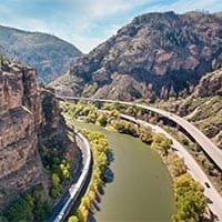
199 miles. 3.25 hours. Drive this route for the sheer wonder of Glenwood Canyon, the prettiest stretch of highway in the U.S. interstate system.

Independence Pass - Denver to Leadville to Aspen
159 miles. 3.25 hours. Believe it or not, this route is the quickest from Denver, despite crossing the Continental Divide three times.

Independence Pass- Denver to Buena Vista to Aspen
185 miles. 4 hours. The longest route from Denver includes views of 17 of Colorado’s 14,000-foot peaks, and follows the Arkansas River for a good stretch.
Highlights Off I-70
Taking I-70 from Denver to Aspen is the easiest (and often quickest) route. Just because you miss the mountain passes does not mean you miss the views. This drive is filled with beautiful places to stop and stretch your legs along the 3.25 hour drive.

Red Rocks Park and Amphitheatre
Distance from Denver: 15 miles
Just as you start to climb into the mountains west of Denver, you reach Exit 259 for Morrison, and the iconic Red Rocks Park and Amphitheatre. Long considered one of the best outdoor concert venues in the world, Red Rocks has not only attracted the likes of the Beatles, Grateful Dead, Odesza, Dave Matthews, Chris Stapleton, and many of today’s trendiest acts, but it doubles as a city park during the day. Climb into the legendary amphitheater and perform a few sun salutations before returning to the road.

Mining Towns
Distance from Denver: 30 miles (Idaho Springs); 45 miles (Georgetown); 47 miles (Silver Plume)
A former gold boomtown, Idaho Springs is a great spot to fuel up, grab lunch at the local Tommyknocker Brewery, or shop at the many small mom-and-pop stores. Visit the historic Argo Gold Mine and Mill, and then explore the other mineral that prompted a boom to Colorado’s 19th century economy — silver — by visiting Georgetown just up the valley. Just beyond the town (and a ways up the hill at Silver Plume) is the Georgetown Loop Railroad. This narrow-gauge railroad is pulled by an historic steam engine. Passengers ride in open carriages through the forest, past mines, and over the impressive Devil's Gate High Bridge.

Hidden Gem: Shrine Pass Road
Distance from Denver: 82 miles
The climb to the summit of Vail Pass on I-70 is long, gradual and certainly memorable. Passing through open alpine meadows, reddish cliffs, and stands of lodgepole pine and spruce, you soon reach the second-highest point on the interstate system (Eisenhower Tunnel, which you just pulled through, is the highest). Pull off at the rest area, and — if its July — drive a few miles on Shrine Pass Road for some of Colorado’s most vivid wildflower displays.

Glenwood Canyon
Distance from Denver: 142 miles
Arguably the most beautiful part of the drive, Glenwood Canyon offers a front-row seat to the mighty power of the Colorado River. In many ways, this rugged canyon is a precursor of the Colorado River's later work at the Grand Canyon, several hundred miles downstream. Stop off at the Grizzly Creek rest area to take in the scene, and marvel at the engineering of the highway’s many bridges, viaducts and tunnels. When it was complete in 1992 after decades of construction, the Glenwood Canyon stretch of I-70 marked the completion of the Interstate Highway System. The canyon is popular with rafting outfitters.

Roaring Fork Valley
Distance from Denver: 178 miles (Basalt) and 199 miles (Aspen)
From Glenwood Springs, the drive along Colorado Highway 82 into the Roaring Fork Valley is stunning to say the least. You are immediately greeted by the beloved Mount Sopris, a burly peak that rises above Carbondale and which acts like a compass point for locals year-round. The town of Carbondale is charming and filled with eclectic eateries and shops worth exploring. Midway up the valley is Basalt, where the iconic fly-fishing hot spot, the Fryingpan River, flows into the Roaring Fork, a favorite for rafters. After a short stretch through a pretty, forested canyon, you reach the upper valley where a right turn will take you to Snowmass. Aspen lies just ahead, at the base of Aspen Mountain.
Highlights Off Co. Hwy 91
In the "Independence Pass - Denver to Leadville to Aspen" route, the drive begins on I-70 to Copper Mountain, and then exiting onto Highway 91, this road trip take you to the highest elevation town in the U.S, Leadville, Colorado. From there, a short drive to Twin Lakes take you up and over Independence Pass to Aspen.

Leadville
Distance from Denver: 101 miles
After traveling a lonely but scenic stretch of highway over Fremont Pass, Colorado Highway 91 descends into the headwaters of the small but soon-to-be-mighty Arkansas River, and delivers you to the historic silver mining town of Leadville. At 10,152 feet above sea level, this is officially the highest incorporated town in the U.S. Visible to the southwest (and towards Aspen), if the highest mountain in Colorado, Mount Elbert. Western history buffs will delight in Leadville’s historic sites, especially the National Mining Hall of Fame, which includes the famous Matchless Mine.
Highlights Off U.S. Hwy 285, U.S. Hwy 24 and Co. Hwy 82
The last and longest route to Aspen, "Independence Pass- Denver to Buena Vista to Aspen", is sure to give you an amazing tour of what Colorado has to offer. If you have a little extra time to make the drive, this route is guaranteed to impress.

Kenosha Pass
Distance from Denver: 65 miles
The drive along U.S. Highway 285 west of Denver can feel like a slow build-up to the grandeur of the Rockies, with forested foothills, elk-laden meadows and gurgling streams lining much of the route. At 10,000-foot-high Kenosha Pass, you reach a pleasant lake where moose are often spotted, and where aspens surround the scene. From here on, the route is lined with vistas, but you must first cross the high-altitude basin known as South Park which is lined with soaring alpine peaks.

Arkansas River Valley
Distance from Denver: 123 miles (Buena Vista)
Descending into the Arkansas River Valley, it is easy to be humbled by the grandeur of the mountain range to the west. Called the Collegiate Peaks, this chain of mountains — many topping the 14,000-foot level — take their name after many of the nation’s top colleges. That’s Mount Princeton in front of you as you start to turn right onto U.S. Highway 24 north. Flowing to your left is the Arkansas River, one of the most thrilling and popular whitewater rafting rivers in the West. Lowkey Buena Vista is a great spot to stop for lunch.

Independence Pass
Distance from Denver: 139 miles (Continental Divide Route) or 165 miles (14er Route)
In between Buena Vista and Leadville, turn left and head west on Colorado Highway 82 towards Twin Lakes. You are almost to Aspen! But first you must pass underneath the south slope of Colorado’s tallest peak, Mount Elbert, and snake your way up the daunting, hairpin turns of Independence Pass, one of North America’s most unique paved roads. Beaver ponds and beautiful, lush alpine meadows are just a precursor to the splendors of Aspen on the other side. At the top, you’ve reached the Continental Divide once again. Pull over and see if you can spot the famous twin summits of the Maroon Bells on the horizon. A long descent off the pass leads you into downtown Aspen.
You Might Also Like

Snowmass
Snowmass is summer central in the Roaring Fork Valley. The Lost Forest, Snowmass Bike Park, Camp Aspen Snowmass, delicious food on the mountain at Elk Camp, and dozens of hiking and biking trails to explore.


